
News
27 March 2024
Update on Outline Planning Applications – Summer 2024
Further to our update in January 2024, we would like to take this opportunity to update everyone who has taken an interest in the proposals...
10 January 2024
Update on the Outline Planning Applications
Due to ongoing technical work, the submission of Outline Planning Applications to Lichfield District Council will now take place in Spring 2024...
6 November 2023
Consultation Closed
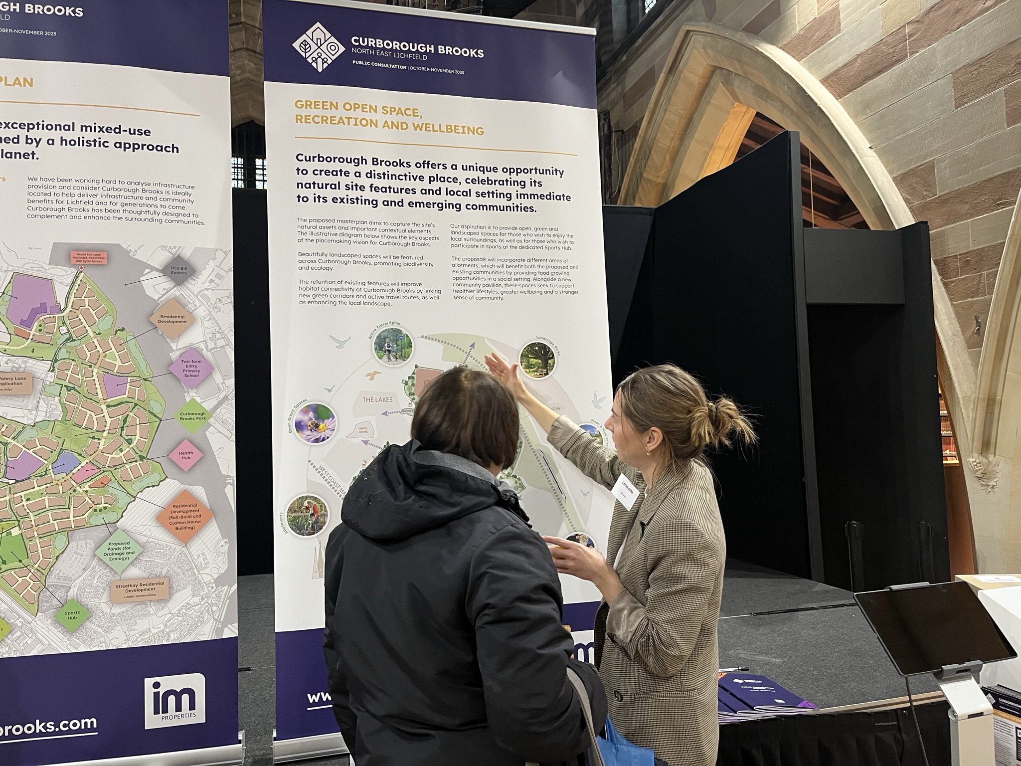
Thank you to everyone who shared their feedback and attended the public consultation events to discuss the early proposals for Curborough Brooks....
Downloads
- Consultation Flyer View/Download
- Public Consultation Booklet View/Download
- Webinar Presentation View/Download
- Public Webinar - 23rd October 2023 View/Download
- Public Webinar - 24th October 2023 View/Download
- Consultation Banners View/Download
Q&A
As with any potential new development, there are always lots of questions. While we undertake ongoing technical work many aspects of the proposals will continue to evolve. However, we have pulled together a Q&A below, which will continue to be updated as we move throughout the planning process.
About Curborough Brooks
The site was part of the Strategic policy SHA1: North of Lichfield Strategic Housing Allocation (Strategic Policies SP1, SP12). The land to the north of Lichfield was allocated for the focus of new residential growth delivering approximately 3,300 homes within the settlement. On Tuesday 17 October 2023, Lichfield District Council members voted to withdraw the proposed draft Local Plan 2040 from examination.
Over the past five years, IMDL has been working with Lichfield District Council and Staffordshire County Council collaboratively on the development of land at Curborough Brooks. The proposals still play a vital role in the growth of Lichfield, delivering new housing and necessary key infrastructure. Therefore, the scheme is still worth the investment to move forward to deliver much-needed homes, including 40% affordable homes, as well as schools and health facilities.
The land is not Green Belt land.
The majority of the site is agricultural land.
Outline Planning Applications will be submitted to Lichfield District Council in Summer 2024. An Outline Planning Application seeks to establish whether the principles and nature of a proposed development would be acceptable to the Local Planning Authority before a fully detailed proposal is put forward.
If and once approved, applications will be made for ‘Reserved Matters’, which will set out further information and detailed designs, underpinned by the approved Outline Planning Application.
Curborough Brooks will be developed by a number of house-builders and specialist builders over the next 15-20 years in phases. A Phasing Plan will be coordinated to ensure that key infrastructure is delivered in a timely manner, which will include the delivery timeframes for the new homes.
Our consultation, which was held in October and November 2023, gave us a good insight into the local community’s views, comments and feedback on the emerging masterplan. All the feedback received has been shared with the team and is being actively reviewed while further developing the proposals. Although our formal consultation period has closed, if you would like to talk to the team, please do get in touch with us.
A Statement of Community Involvement (SCI) will be submitted with the Outline Planning Applications, which will detail the consultation process, feedback received and how this has been considered in developing the masterplan.
Once submitted, Lichfield District Council will undertake its own consultation where you will have the opportunity to comment directly on the application to the Council.
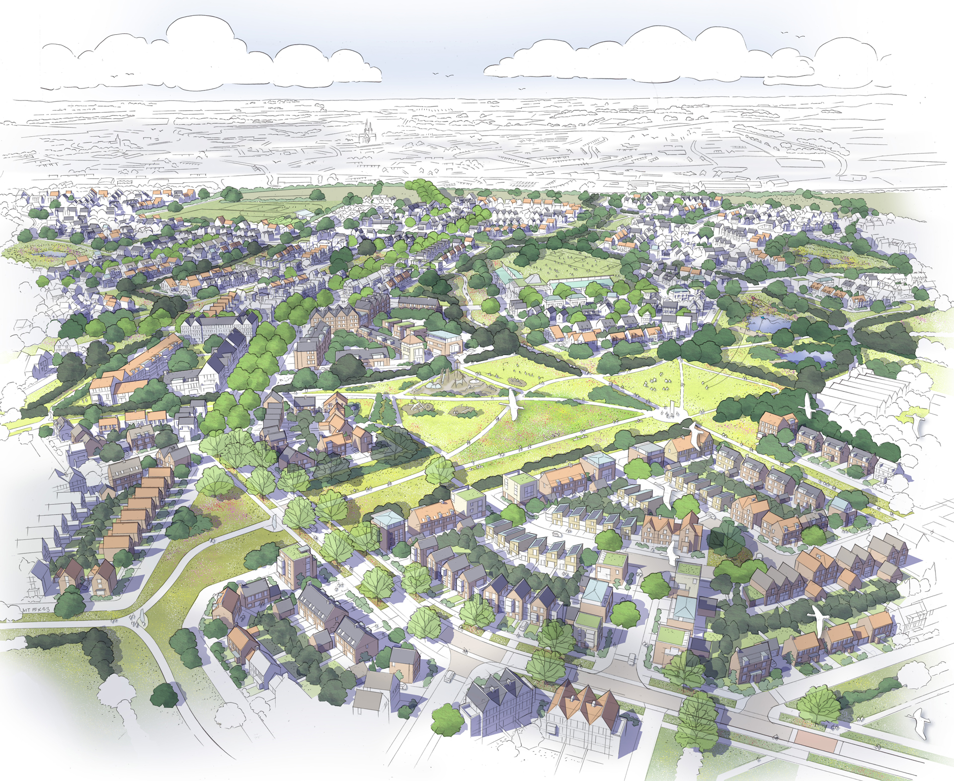
Overall Masterplan and New Homes
We are proposing 2,900 much-needed new homes, which will be for everyone from families to first-time buyers, downsizers to young professionals.
Curborough Brooks has the potential to deliver 40% affordable homes, which will include a mix of affordable homes for rent and affordable routes to home ownership (such as shared ownership). The specific mix will be agreed with the Council.
In response to feedback and following our public consultation in 2023, the provision of affordable housing has increased from 20% to 40%.
Delivering larger strategic sites, rather than smaller scale proposals, will allow for thoughtful placemaking to support local growth. Due to the size of the site, the proposals are able to provide new important and necessary infrastructure. Amid a national housing crisis and cost of living crisis, there is a need to build more homes and infrastructure to serve the needs of communities today and in the future.
The detail of the masterplan will come forward through ‘Reserved Matters’ Applications, subject to approval of the Outline Planning Applications, which will detail the scale and design of the new homes and facilities. The Outline Planning Applications will be supported by a series of Parameter Plans, which will include likely building heights. It is likely that the mixed-use centre, surrounding properties and the three schools will feature buildings of three to four storeys. The proposals also include approximately 45% open space.
Infrastructure, Services and Amenities
The proposals provide sites for a new eight-form entry secondary school and two sites for primary schools (one three-form entry and one two-form entry).
The proposals also include a site for a Health Hub, which will create a centre of complementary uses. The Health Hub includes provision for specialist later living and care homes, which give people the flexibility to live within the community while receiving the care that they need. The Health Hub can also deliver a range of complementary uses such as space for a GP surgery, gym and community centre.
As part of the proposals, a Sports Hub is also proposed, with high-quality sport facilities and pitches as well as complementary facilities such as a pavilion to include storage, changing facilities and car parking.
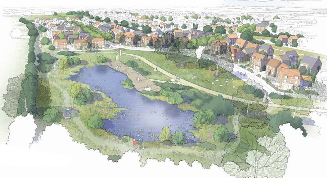
Centred around a new green park will be a local centre with shops, services and facilities for local residents and visitors to enjoy. The park will be open and inviting for all, with clear and safe routes throughout while incorporating existing and proposed green infrastructure. At this central location, the park will provide a variety of spaces for people to relax, exercise and play. Areas of significant green space are proposed to encourage healthy, active lifestyles as well as providing micro-climate benefits. Details on the types of shops and amenities will be agreed at ‘Reserved Matters’ stage.
Once approved, Curborough Brooks will be developed over a number of years in phases. A Phasing Plan will be coordinated to ensure that key infrastructure is delivered in a timely manner, which will include the delivery timeframes for the schools.
Staffordshire County Council’s aspirations are that the much-needed secondary school will be open for pupils in September 2028.
The land for the GP surgery/Health Hub will be transferred to the NHS Integrated Care Board (ICB) via the S106 process and they will manage the construction and staffing. Further detail on the Health Hub will be agreed at the ‘Reserved Matters’ stage, should the Outline Planning Applications receive future planning approval.
Landscaping, Ecology and Biodiversity
The landscape masterplan considers the site’s context, its existing and emerging setting, existing topography, existing landscape features such as hedgerows, trees and ponds, and existing views. The key objective is to retain, enhance and celebrate the best parts of the existing landscape and create a multi-functional and enlivened network of spaces and places.
Our appointed heritage consultant has been looking at key heritage assets and their relationship to Curborough Brooks to ensure the masterplan takes into account heritage sensitivities and responds to them positively.
Approximately 45% of Curborough Brooks will be open green space. The masterplan proposals will provide approximately 78 hectares of public open space, which is equivalent to around 109 football pitches. As well as the new park, Sports Hub and local centre, this will include recreational space, allotments, green public open spaces, retained woodlands, landscaping, and children’s play areas.
The existing hedgerows, ecological features and woodland network will be retained and enhanced alongside providing new species-rich habitats, which will result in a Biodiversity Net Gain at Curborough Brooks.
The retention of these features will ensure improved connectivity and create green corridors and active travel routes while improving the landscape and habitat connectivity.
In addition to the retention of ecological interest features and the newly created, species-rich habitat, the proposals include a number of other biodiversity considerations. These comprise a range of bird and bat boxes installed on suitably mature trees catered for a range of species, integrated bat and bird features within new structures, green/brown invertebrate roofs, a sensitive lighting strategy to ensure continued foraging opportunities for the local bat population, and enhancement measures for the Curborough and Mare Brook corridors. The measures will not only safeguard the interests of a large range of faunal groups known, but also create new opportunities, which are currently absent in any significant numbers, such as reptiles and amphibians.
Climate change and biodiversity are interrelated challenges, and the proposals have been designed to deliver multi-functional benefits for people and planet. Homes themselves will be designed to be energy efficient, creating less energy demand and minimising emissions through low and zero carbon energy sources. The design of all homes will be assessed for overheating risk, and measures will be taken to adapt to future periods of high temperature.
Encouraging the uptake of active travel will also reduce emissions associated with travel. There are a number of amenities and services included in the proposals that can be accessed by walking, wheeling and cycling.
In addition, a range of active travel routes are situated within green corridors, which serve to link areas of open spaces and provide habitats. The development will include a wide range of biodiversity features to provide habitats, as well as providing an area for community food growing. Green spaces are designed around a strong network of existing hedgerows, with mature and veteran hedgerows and trees.
There are a number of public rights of way that cross the site, including the Erasmus Darwin Footpath, which broadly crosses east-west. As a result of the proposed development, a number of public rights of way will be realigned through the development, ultimately changing their setting and the users experience.
For example, the Erasmus Darwin footpath, which currently crosses arable fields, would instead cross a new park. The footpath will take in views of Lichfield City to include the Cathedral with opportunities to rest and take in the panoramic views and the heritage of the local area.
The assessments undertaken show that the majority of the site is in Flood Zone 1, which has the lowest risk of flooding. Some small areas of the site fall within Flood Zones 2 and 3. The intention is that development is avoided in the higher risk areas and that the new development does not increase the risk of flooding elsewhere, by incorporating Sustainable Urban Drainage Systems (SuDs) throughout.
Surface water will be managed in a way that is sympathetic to the existing natural arrangement. Watersheds, drainage ditches and larger watercourses will be respected and maintained wherever possible. Intelligent design will be undertaken to ensure that the principal watercourses, including the Curborough Brook and Mare Brook, will not be adversely affected and any drainage and ecology functions of these will not be impacted.
The Outline Planning Applications will include a Flood Risk Assessment and Drainage Strategy.
Highways and Transport
We are proposing a new green Active Travel Spine running north to south through the development, which will provide a dedicated, attractive walking, wheeling and cycling links to key destinations within the site, including the local centre, schools and key open spaces.
This main corridor links into a network of active travel routes integrated along streets, green corridors and open spaces, creating a development that encourages walking and cycling. The active travel routes will connect to the existing routes around Lichfield, with improvements provided where required, linking with key destinations local such as Fradley, the City Centre and train stations.
Access to the site at present is provided by a number of routes, including pedestrian access via existing public rights of way that cross the site.
We are proposing new road infrastructure that will connect to the south via Netherstowe Lane, to the north via Wood End Lane and through to the west to the forthcoming ‘The Lakes’ development.
Vehicle access is not proposed at present through the Streethay development. However, pedestrian links are included in the proposals.
We understand that highways and transport is a key concern from the local community. We have been engaging key stakeholders to identify improvements that can be made to the local highway network to improve flow, safety and pressure points.
Our transport consultant is undertaking traffic modelling to help inform the Transport Assessment, which will be submitted alongside the Outline Planning Applications.